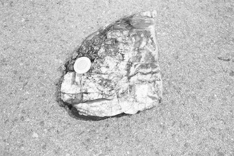
A grab sample from a boulder laced with visible gold has returned the highest concentration of gold ever reported in New Brunswick at 1,320 grams per tonne (38.5 oz. per ton).
Susan Johnson, a provincial geologist with the Department of Natural Resources discovered the boulder this summer while conducting a mapping project in the south-central part of the province, 15 km north of Sussex. The new discovery was first announced in late September, and so far about 150 claims covering 24 sq. km have been staked in the immediate area.
“It opens up a new area for exploration,” Johnson says.
Provincial government geologists have long argued that New Brunswick, more noted for its base metal and potash potential, is greatly underexplored for gold and offers tremendous potential for new discoveries. Gold mineralization has been documented in nearly all the main tectonostratigraphic zones of the province in units ranging in age from Neoproterozoic to Carboniferous.
While mapping the bedrock along Harry Brook, Johnson came across a 35 by 20-cm sub-angular to sub-rounded quartz boulder about 500 metres downstream from an anomalous stream-sediment sample identified on regional geochemical maps published in 1988 by the Geological Survey of Canada (GSC). The sample ran 16 parts per billion (ppb) gold — one of the highest geochemical values in the area.
The quartz vein boulder contains pinhead-sized specks of visible gold, which appear to be associated with hematite-filled microfractures. Elevated values of mercury and silver are present. A second sample from the same boulder assayed 740 grams gold per tonne (21.6 oz.), with anomalous zinc and lead values.
“It is anticipated that the new find will greatly enhance exploration activity in the older, metal-rich Early Paleozoic belts north of Sussex,” says Malcolm McLeod, a provincial geologist and manager of the department’s Geological Surveys South Branch. “Pending further research focused on the timing of the mineralizing event, it could also have a positive impact on exploration for gold over a much broader area . . . in southern New Brunswick.”
The Harry Brook area is on the southern flank of the New Brunswick platform, an uplifted block of Pre-Carboniferous basement overlain by a thin cover of Carboniferous strata. Upper Mississippian conglomerates of the Shin Formation (part of the Mabou Group) directly underlie the area where the mineralized boulder was found. The Mabou Group is the oldest Carboniferous unit exposed on the platform in this area.
Hematized mafic pyroclastics rocks that outcrop on Harry Brook to the north and west of the gold-bearing boulder are correlated with Neoproterozoic rocks that occur on Beatty Brook in the southwest corner of the mapping project area. Further onto the platform about 2.5 km northwest of the gold-bearing boulder, a newly uncovered basement inlier contains lithologies that are similar, although not identical to, felsic volcanic rocks associated with rhyolite domes in the Late Cambrian-Early Ordovician Annidale Group. The inlier consists of vesicular to non-vesicular rhyolite, rhyolite breccia, microgranite and a strongly magnetic, fine-grained mafic plug.
The rhyolite contains quartz-filled vugs, chalcedony veins and a stockwork of quartz and hematite veinlets. A sample of the rhyolite assayed 965 ppb gold.
“Although the basement, or the boundary between the differing basement units, is likely the original source of the gold-bearing quartz veins, a secondary, or paleoplacer origin for the boulder is also a prime target,” concludes Johnson. “On Harry Brook and its tributaries, and in areas underlain by Shin conglomerate to the northeast and southwest, cobbles and boulders of mafic pyroclastic rocks, rhyolite and vein quartz similar to that carrying the high-grade gold were all observed as clasts in the Shin conglomerate and as angular float — indicating that the gold-bearing quartz boulder could have been derived from the Shin Formation.”
The Harry Brook area is about 10 km northeast of the Marrtown gold showing and 20 km northeast of several low-grade gold occurrences in the Annidale-East Scotch Settlement area. Several narrow shear zones containing low-grade gold were intercepted at the Marrtown prospect during drilling there in 2002, including 1.9 metres of 1.4 grams gold.
Clarence Stream
Much of the gold exploration activity in southern New Brunswick has focused on the Clarence Stream area, some 100 km west of Harry Brook, where
Clarence Stream is a grassroots discovery located 70 km southwest of Fredericton in an area better known for its tin-tungsten deposits — the past-producing Mount Pleasant tungsten-molybdenum mine is only 10 km to the east.
Since optioning the property in 1999 from local prospector Reginald Cox, Freewest has traced the source of scattered gold-bearing boulders and frost-heave sub-crop to a number of mineralized zones along the northwestern fringe of the Saint George Batholith, a large, high-level, multi-phase granitic batholith.
Cox had discovered gold-bearing boulders in 1998 while prospecting along newly built forestry roads, with the aid of data derived from a 1992 regional stream-sediment geochemical survey by the GSC. The survey revealed a prominent cluster of gold-in-stream-sediment anomalies close to the property, with values up to 341 ppb. Grabs from the boulders assayed as high as 45.6 grams, and carried arsenic and antimony.
Five mineralized sub-zones — West, Cox, N, Central and East — were uncovered over a 2-km-long distance in northeast-striking shear zones that crosscut a Silurian-age volcanic metasedimentary sequence within the contact aureole of the nearby Magaguadavic phase of the Saint George Batholith. The five intrusion-related zones occur in steeply dipping en echelon and sheeted quartz vein systems, with associated veinlet stockwork, within sheared gabbroic and metasedimentary rocks.
Freewest completed 64 drill holes in the main discovery area in 2001. Some of the best results came from the Central zone, highlighted by 15.1 grams gold per tonne across 21 metres, 7.8 grams over 14.9 metres, and 21.5 grams across 9.5 metres. The Central zone was tested by 26 holes over a 150-metre strike length and to a depth of 250 metres. A potential inventory of some 456,884 tonnes grading 8.74 grams (uncut), equivalent to 137,000 oz. gold, was calculated to a depth of 150 metres. Although the zone narrows noticeably at deeper levels, it remains open. The Central quartz vein zone is on a high-strain structure that pinches and swells, but averages about 8.5 metres in thickness.
In the last several years, Freewest has shifted its exploration efforts to Anomaly A, a gold-arsenic-antimony anomaly measuring 2.5 km long and, in places, up to 700 metres wide. Local mineralized float, some carrying visible gold and bonanza-grade values of up to 418 grams gold per tonne (12.2 oz.), was discovered by prospecting in 2001. Backhoe trenching and an overburden drilling campaign helped Freewest zero in on the MW, AD, 93 and Murphy occurrences. A broad induced-polarization (IP) chargeability anomaly outlines the general location of these zones.
The Anomaly A zones are more distal to the Saint George Batholith, about 3 to 4 km out, and occur in a different tectonic setting than that of the original discoveries. The mineralized zones of Anomaly A are hosted in an Ordovician-age metasedimentary sequence of polydeformed greywackes and argillites of the Kendall Mountain Formation.
Throughout 2002-2004, Freewest completed about 174 holes in the Anomaly A area, the greatest density of drilling occurring on the MW and AD zones. The AD zone is a strongly altered sericitic zone in folded greywacke, mudstone and argillite that dip shallowly to the north, whereas
the MW zone dips shallowly to the south.
Gold occurs in flat-lying zones of strong quartz veining, quartz flooding and stockwork, containing locally abundant stringer and semi-massive stibnite, arsenopyrite, with local sphalerite, chalcopyrite and visible gold. The best grades are where the veins are brecciated and fractured, and there has been a re-mobilization of sulphides infilling the fractures.
The MW shoot is estimated to contain a potential near-surface 320,550 tonnes averaging 5.76 grams, equal to 61,546 oz. gold, while the AD zone comprises a potential 276,626 tonnes averaging 5.84 grams, for an additional 53,849 oz. An exceptionally high-grade intercept was pulled from the AD zone in 2003. The hole ran 16.4 grams gold per tonne and 11.7% antimony over a core length of 15.2 metres, including 32.2 grams gold and 23.1% antimony across 7.2 metres.
Basin-shaped structure
Freewest’s drilling has demonstrated the two zones are part of the same flat-lying, basin-shaped structure measuring 400 by 400 metres. The deepest hole along the keel of this basin is only 75 metres. Accordingly, Freewest believes all four occurrences may be connected along the same F2 controlling structure. This structure has been folded coaxially by F3, accounting for the changes in the direction of dip.
Freewest’s 2004 fiscal year-end report noted that the large area separating the AD-MW zone from the 93 and Murphy zones make the potential for increasing the gold resource at Anomaly A excellent.
In a concerted effort to increase the mineral resource at Clarence Stream so the project can be advanced towards potential open-pit production, Freewest returned to the original discovery area in 2005 and targeted several untested gaps between the main zones, including a 600-metre-long section between the Central and East zones.
The 2005 drilling resulted in the discovery of the A zone, 100 metres to the east of the Central zone. The A zone may be an extension of the Central zone, or a parallel gold zone. Drilling has defined the new zone over a 250-metre strike length and to a vertical depth of 100 metres. A number of high-grade intercepts have been recorded, including 32.2 grams across 5 metres (including 1.5 metres of 101 grams), 5.15 grams over 6.5 metres (including 0.5 metre of 41.5 grams, 7.53 grams across 3.35 metres (including 0.7 metre of 31.7 grams), 5.57 grams over 6.5 metres (including 1 metre of 38.1 grams) and 7.27 grams across 5 metres (including 0.5 metre of 55.4 grams).
The mineralized A zone occurs within and adjacent to a metagabbro unit, which ranges in thickness from 5 to 12 metres. The better gold grades occur within bleached gabbro and adjacent metasedimentary rocks, characterized by the presence of disseminated and fracture-filled native antimony and, likely, aurostibite. The A zone remains open down-plunge to the west.
Freewest also encountered encouraging results while further testing the N zone, hitting 20 metres averaging 3.44 grams (including 10.9 grams across 3.5 metres), 8.7 metres of 8.35 grams, 12 metres of 4.39 grams, 6.5 metres averaging 7.27 grams, and 21.5 metres grading 4.28 grams. To date, the N zone has been drilled over a 125-metre strike length and to a depth of 150 metres. It has a pipe-like configuration, dips sub-vertically and is completely open at depth. The N zone consists of quartz stockwork and veins hosted in altered metasedimentary and volcaniclastic rocks intruded by gabbroic sills.
The company has commissioned an independent National Instrument 43-101 compliant technical report, which will focus on establishing an updated resource estimate for the Clarence Stream project as a whole.
New Brunswick has an excellent mineral portfolio and one that I hope to see being developed in the years to come. For anyone that is interested in exploring more on New brunswick Mineral deposits I would ask that you come support the prospectors of New Brunswick who are hard at work finding gold, copper, tungsten and Rare earth elements. You can help support us by visiting our webpage at http://www.nbprospecting.com and exploring the vast portfolio of minerals our province is currently offering.
This publication is released by the department of energy and mines and promoted by prospectors like myself.
Thanks for the Great read.
Great read, good information !!