Let’s start this story close to its end with an April 27, 1967, front-page headline from Tucson’s Arizona Daily Star: “Papagos lease site for copper mine,” followed by a sub-headline: “Indians to gain self-sufficiency.”
And now to the beginning: After a few years wintering in Yellowknife and working in the Eastern Arctic Barren Lands for long, uninterrupted stints, I was ready for a change. Pounding the streets of Toronto led to a few job offers, the most interesting from Hunting Survey Corp., a U.K.-based group specializing in mineral surveys in undeveloped countries.
This job might have landed me in some Middle Eastern backwater, but, as it happened, they sent me to Tucson, Ariz., where they were just completing work on their Apache Indian Reservation survey, and were starting another project on the Papago Reservation, a vast tract of Sonoran Desert between Tucson and Ajo, its south margin following the Arizona-Mexico border.
Hunting’s modus operandi for these projects was to seek investment groups to finance the work, with the investors’ objective being majority ownership in any discovery that might result.
Hunting’s U.S. manager, headquartered in New York City, was responsible for designing the projects and, more importantly, selling them. One of Hunting’s main selling points was its expertise in advanced technology exploration. And the U.S. country manager was perfect for this job: a geologist, but also a super salesman, who was enamoured of high technology.
To carry out the Papago work, a small office was set up in Tucson staffed by a manager and a few grunts like myself.
To help guide the investors, they hired a world-renowned professor of economic geology from the highly esteemed California Institute of Technology. When this guy talked, people listened, and his opinions were sacrosanct.
The special tool for Papago was the use of recently developed, high-resolution aerial photos to map geology and delineate extensive altered areas that might indicate porphyry copper deposits.
But, after many months of following up colour anomalies, we came up empty. Little did we know that this fate was sealed long ago when the reservations were created by the forever corrupt Bureau of Indian Affairs: the boundaries were deliberately drawn to exclude any important mineralized areas.
With these results the professor became negative on the project and might have pulled the plug, but the financers still had a considerable spending requirement to fulfill their lease terms to the tribe.
So the next logical step was to evaluate the many documented meagre old mines within the reservation.
Vekol Hills
Among the many places I was assigned to investigate, the most promising was Vekol Hills, located south of the abandoned Papago village of Kohakt. Here, along the 1.5-mile, southwest-trending outcrop front of the hills were a number of small workings. The outcrop front was bordered to the east and southeast by a gravel-covered pediment grading into a gentle valley, which extended for 10 miles east.
The old Vekol Hills workings were on weak copper-bearing skarns and steep faults within a gently west-dipping section of Paleozoic sediments, mostly limestones, capped by an odd Cretaceous conglomerate formation. The sedimentary rocks were intruded by quartz porphyry and other granitic stocks and dykes.

Historic hand-drawn plan view of the Vekol Hills porphyry copper deposit in Arizona. From M.A. Kaufman.
Only one outcrop poked through the pediment and valley — a somewhat freakish mound of quartzite, about 400 feet in diameter and 15 feet high, situated 1,000 feet southwest from the closest part of the Vekol outcrop front.
Though I was no expert on porphyry copper deposits, it was evident that in many of the districts of the great Southwest U.S. copper province, the mineralizing intrusions rose up through sedimentary sections, which were altered to skarn assemblages, often hosting big parts of the ore deposits.
Though the Vekol showings were puny in comparison to the productive districts, I noted that some of the skarns contained magnetite, and recommended that a magnetic survey be carried out over the Vekol Hills and out into the pediment. I reasoned that magnetic highs might detect skarn occurrences, and magnetic low areas might indicate porphyry-type alteration. The U.S. manager approved and authorized an aerial survey covering the Vekols, and the whole extensive valley to the east.
No definitive magnetic lows were found, but pronounced highs were evident. A real whopper was detected hidden under pediment gravels on the east side of the valley 9 miles east of the Vekols, and a number of lower magnitude highs were found in the Vekol Hills area, the most promising one under the weird quartzite mound and surrounding pediment.
To further investigate the magnetic anomalies, induced polarization (IP) surveys were carried out.
The IP results over the whopper were negative, but the survey over the weak magnetic high around the quartzite hill detected a definite anomaly indicating up to 6% sulphides, 200 feet under the outcrop.
Because of its high magnetic response, the professor and country manager couldn’t resist a first drill hole into the whopper.
But the cause of the response turned out to be an ugly, barren magnetic Tertiary volcanic formation. They considered drilling at the quartzite hill anomaly but closed the door on it. Closely examining the quartzite outcrop underneath the centred IP anomaly would reveal a hungry-looking, dense quartzite cut by a narrow, altered felspar porphyry dyke and a few cracks coated by oxide copper minerals.
They theorized the IP anomaly could be either spurious, or caused by a Pre-Cambrian schist formation thought to underlie the quartzite.
In any case, they would not authorize further drilling, and the project was terminated.
Myself and Quentin Whishaw, the Tucson office manager, vehemently disagreed with their decision, and talked them into at least shopping the property around. Neither of us had any profound knowledge of what might be causing the anomaly, but we simply thought it was foolish — after spending half a million dollars on the project — to not at least drill the only two targets we had found.
At the time Tucson was a hotbed of exploration for porphyry copper deposits, with most major companies keeping offices there, some staffed by up to 30 geologists. So I thought we might find some company willing to take over.
Was I ever wrong! Never, before or since, have I experienced so many shades of derision. The kindest was thigh-slapping laughter, and the meanest was: “No geologist of ethical purity would go around flogging such a dodgy property.” Many times I heard the familiar utterance: “Why should it get better at depth?”
With no hope in sight, I was seriously considering trying to deal with the investors, and blowing my modest savings on a drill hole or two. But I never got the chance.
Suddenly, along came a gallant white knight in the person of consulting geologist David Lowell, who had heard the property was available. Dave served as a listening post for Newmont Mining, which did not maintain a Tucson office. He saw something in our Vekol target that the others missed, and recommended that Newmont acquire it.
Before long, Bob Fulton, Newmont’s exploration manager, was on our doorstep with colleague Arthur Brandt, Newmont’s head geophysicist. After Brandt gave his blessing to the IP anomaly, Fulton’s response was roughly: “There’s a hell of a lot of copper in southern Arizona — let’s put a damned hole into this thing.”
And now, back to the Daily Star headline at the beginning of this long, convoluted story. Newmont shortly thereafter acquired the property and set up a drill rig at the edge of the infamous quartzite mound. They drilled through 200 feet of quartzite and feldspar porphyry, and then, lo and behold, they intercepted several hundred feet of ore.
From then on, it was grid drilling, mostly in ore holes, some ore zones being far shallower than in hole 1, and some ore intercepts up to 1,000 feet thick. The end point was a deposit containing 80 million tons grading 0.6% copper, with recoverable coproducts. This led to the 1967 newspaper headline.
The plan was to develop a 15,000-ton-per-day open pit to operate by 1970, and build a concentrator with concentrates shipped to their San Manuel smelter.
But this would never happen. Unfortunately, Newmont’s plans coincided with sliding copper prices, leading to the awful decade of the 1970s, and the development was stillborn.
During the seventies and thereafter, the tribes were infiltrated by American environmental organizations, and many of them, including the Papagos, became negative on mining developments.
The resource, to this day, remains untouched, and the district remains frozen in time, only partly explored with 1960s geophysical technology.
Geo-logic
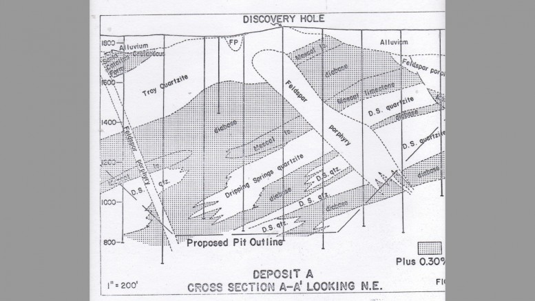
So what in hell is really going on over and under the barren quartzite mound? The outcrop is impermeable Cambrian Troy quartzite — an extremely unfavourable host rock. The Troy is overlain by thick, reactive Cambrian to Mississippian limestones, and underlain by the Proterozoic Mescal limestone and the Dripping Springs quartzite.
Underlying the whole mess is the Archean Pinal schist — the formation that the professor and manager thought caused the IP anomaly. Both the Mescal and Dripping Springs formations have been invaded by extremely thick diabase sills.
At this locality, ascending ore solutions hit a dam at the lower Troy contact, and were deposited in the Mescal limestone, but mostly in the diabase sills both in the Mescal and dripping Springs formations. The primary diabase is slightly enriched in copper, and sucks up water to copper in hydrothermal solutions like a sponge. There are small concentrations of magnetite in the mineralized Mescal formation, but the magnetic anomaly that led us to do the induced polarization survey that found the orebody was mainly caused by the diabase sills.
So this whole discovery was fortuitous. But credit is due to induced polarization geophysics, which was then in its infancy. To my knowledge, this was the first discovery of a new porphyry copper deposit using this tool.
In comparison to other Arizona porphyry copper deposits, the Vekol Hills discovery resembles Magma Copper’s more recently discovered giant Resolution Copper, now owned by BHP and Rio Tinto. This deposit, which tops out at 1,500 metres below surface, contains 1.34 billion inferred tonnes of 1.51% copper and 0.04% molybdenum, as of 2008. It mostly occurs in thick diabase formations within the Mescal limestone section. And north of Resolution in overlying Paleozoic sediments was the old Magma mine, which produced 2.4 billion lb. copper, 40 million oz. silver and 795,000 oz. gold from manto orebodies averaging 5% copper.
While Resolution has clearly found causative intrusions at the bottom of their monstrous orebody, at Vekols, no such source has been identified. The known Vekol Hills resource could represent just a token of what might exist buried under the sedimentary section. I think of what might underlie the Cretaceous conglomerate cut by numerous felsic porphyry dykes capping the sedimentary section north and west of the proven orebody. And I think of the little inclined shaft bordering the gravel-covered basin west of Vekol Hills. My dump assays here were up to 2.66 oz. gold per ton, 55 oz. silver per ton and 14% copper.
Frankly, I would never write this story if my clock were not running out. Possibly, at some future time, the Papago Tribe (now known as the Tohono O’odham Nation) will reopen their land for exploration and mining activity, perhaps if and when the lucrative tribal casino business becomes a burst bubble — hopefully before our sun transforms into a Red Giant.
— M. A. “Mo” Kaufman is a mining geologist in Spokane Valley, Washington State. He can be reached at dv10@comcast.net.
[Editor’s note: We welcome submissions by our readers of interesting, funny or poignant remembrances from their careers in mining. Please send them to: tnm@northernminer.com.]


Be the first to comment on "Odds ‘n’ Sods: Strange discovery under a freakish quartzite mound in Arizona"